
Tropical Cyclone Activity
Atlantic Tropical Outlook

Pacific Tropical Outlook

Atlantic/Gulf of Mexico/Caribbean
Atlantic Tropical Weather Outlook
000
ABNT20 KNHC 301741
TWOAT

Tropical Weather Outlook
NWS National Hurricane Center Miami FL
200 PM EDT Mon Jun 30 2025

For the North Atlantic...Caribbean Sea and the Gulf of America:

Near the Southeastern U.S.:
A frontal boundary is expected to stall and weaken off the southeast
U.S. coast late this week.  An area of low pressure could develop
from the weakening front by the weekend off the southeast U.S., over
Florida, or over the eastern Gulf.  Some gradual tropical or
subtropical development could occur thereafter as the low moves
little.
* Formation chance through 48 hours...low...near 0 percent.
* Formation chance through 7 days...low...20 percent.

$$
Forecaster Blake
There are no tropical cyclones at this time.
No tropical cyclones as of Mon, 30 Jun 2025 22:30:07 GMT
Eastern Pacific
Eastern North Pacific Tropical Weather Outlook
000
ABPZ20 KNHC 301741
TWOEP

Tropical Weather Outlook
NWS National Hurricane Center Miami FL
1100 AM PDT Mon Jun 30 2025

For the eastern and central North Pacific east of 180 longitude:

Active Systems:
The National Hurricane Center is issuing advisories on Tropical
Storm Flossie, located in the eastern Pacific basin a couple of
hundred miles offshore the coast of southwestern Mexico.

South of Southwestern Mexico:
An area of low pressure could form several hundred miles offshore of
southwestern Mexico late this week. Some gradual development of this
system is possible thereafter while it moves generally
west-northwestward.
* Formation chance through 48 hours...low...near 0 percent.
* Formation chance through 7 days...low...30 percent.

$$
Forecaster Kelly/Nepaul
Summary for Tropical Storm Flossie (EP1/EP062025)
...FLOSSIE FORECAST TO BECOME A HURRICANE TONIGHT OR TUESDAY... ...LOCALLY HEAVY RAINFALL POSSIBLE ALONG COASTAL SOUTHWESTERN MEXICO... As of 3:00 PM CST Mon Jun 30 the center of Flossie was located near 16.2, -103.6 with movement NW at 12 mph. The minimum central pressure was 996 mb with maximum sustained winds of about 65 mph.
Tropical Storm Flossie Public Advisory Number 7
Issued at 300 PM CST Mon Jun 30 2025 074
WTPZ31 KNHC 302040
TCPEP1

BULLETIN
Tropical Storm Flossie Advisory Number   7
NWS National Hurricane Center Miami FL       EP062025
300 PM CST Mon Jun 30 2025

...FLOSSIE FORECAST TO BECOME A HURRICANE TONIGHT OR TUESDAY...
...LOCALLY HEAVY RAINFALL POSSIBLE ALONG COASTAL SOUTHWESTERN
MEXICO...


SUMMARY OF 300 PM CST...2100 UTC...INFORMATION
----------------------------------------------
LOCATION...16.2N 103.6W
ABOUT 170 MI...270 KM SW OF ZIHUATANEJO MEXICO
ABOUT 200 MI...320 KM SSE OF MANZANILLO MEXICO
MAXIMUM SUSTAINED WINDS...65 MPH...100 KM/H
PRESENT MOVEMENT...NW OR 305 DEGREES AT 12 MPH...19 KM/H
MINIMUM CENTRAL PRESSURE...996 MB...29.42 INCHES


WATCHES AND WARNINGS
--------------------
CHANGES WITH THIS ADVISORY:

None.

SUMMARY OF WATCHES AND WARNINGS IN EFFECT:

A Tropical Storm Warning is in effect for...
* Punta San Telmo to Playa Perula

A Tropical Storm Watch is in effect for...
* East of Punta San Telmo to Zihuatanejo
* North of Playa Perula to Cabo Corrientes

A Tropical Storm Warning means that tropical storm conditions are
expected somewhere within the warning area within 36 hours.

A Tropical Storm Watch means that tropical storm conditions are
possible within the watch area, generally within 48 hours.

Interests elsewhere in southwestern Mexico should monitor the
progress of Tropical Storm Flossie.

For storm information specific to your area, please monitor
products issued by your national meteorological service.


DISCUSSION AND OUTLOOK
----------------------
At 300 PM CST (2100 UTC), the center of Tropical Storm Flossie was
located near latitude 16.2 North, longitude 103.6 West. Flossie is
moving toward the northwest near 12 mph (19 km/h). A northwest to
west-northwest motion should continue over the next few days.

Maximum sustained winds are near 65 mph (100 km/h) with higher
gusts. Steady to rapid strengthening is forecast during
the next couple of days, and the system is expected to become a
hurricane tonight or Tuesday.

Tropical-storm-force winds extend outward up to 90 miles (150 km)
from the center.

The estimated minimum central pressure is 996 mb (29.42 inches).


HAZARDS AFFECTING LAND
----------------------
Key messages for Tropical Storm Flossie can be found in the Tropical
Cyclone Discussion under AWIPS header MIATCDEP1 and WMO header
WTPZ41 KNHC.

RAINFALL: Tropical Storm Flossie is expected to produce rainfall
totals of 3 to 6 inches, with isolated maximum totals of 10 inches,
across portions of the Mexican states of Oaxaca, Guerrero,
Michoacán, Colima, and Jalisco through Wednesday. This rainfall
could lead to isolated life-threatening flooding and mudslides,
especially in steep terrain.

For a complete depiction of forecast rainfall associated with
Tropical Storm Flossie, please see the National Weather Service
Storm Total Rainfall Graphic available at
hurricanes.gov/graphics_ep1.shtml?rainqpf

WIND: Tropical storm conditions are expected within the warning
area, and are possible within the watch areas, tonight through
Tuesday.

SURF: Swells generated by Flossie will affect portions of the coast
of southwestern Mexico during the next few days. These swells are
likely to cause life-threatening surf and rip current conditions.
Please consult products from your local weather office.


NEXT ADVISORY
-------------
Next intermediate advisory at 600 PM CST.
Next complete advisory at 900 PM CST.

$$
Forecaster Kelly
Tropical Storm Flossie Forecast Advisory Number 7
Issued at 2100 UTC MON JUN 30 2025 073
WTPZ21 KNHC 302040
TCMEP1

TROPICAL STORM FLOSSIE FORECAST/ADVISORY NUMBER   7
NWS NATIONAL HURRICANE CENTER MIAMI FL       EP062025
2100 UTC MON JUN 30 2025

TROPICAL STORM CENTER LOCATED NEAR 16.2N 103.6W AT 30/2100Z
POSITION ACCURATE WITHIN  30 NM

PRESENT MOVEMENT TOWARD THE NORTHWEST OR 305 DEGREES AT  10 KT

ESTIMATED MINIMUM CENTRAL PRESSURE  996 MB
MAX SUSTAINED WINDS  55 KT WITH GUSTS TO  65 KT.
50 KT....... 40NE  40SE   0SW   0NW.
34 KT....... 80NE  70SE  50SW  60NW.
4 M SEAS....120NE  90SE  30SW  90NW.
WINDS AND SEAS VARY GREATLY IN EACH QUADRANT.  RADII IN NAUTICAL
MILES ARE THE LARGEST RADII EXPECTED ANYWHERE IN THAT QUADRANT.

REPEAT...CENTER LOCATED NEAR 16.2N 103.6W AT 30/2100Z
AT 30/1800Z CENTER WAS LOCATED NEAR 15.9N 103.2W

FORECAST VALID 01/0600Z 17.0N 105.0W
MAX WIND  70 KT...GUSTS  85 KT.
64 KT... 10NE   0SE   0SW   0NW.
50 KT... 40NE  40SE  10SW  20NW.
34 KT... 90NE  70SE  50SW  70NW.

FORECAST VALID 01/1800Z 17.9N 106.7W
MAX WIND  80 KT...GUSTS 100 KT.
64 KT... 10NE  10SE   0SW  10NW.
50 KT... 40NE  30SE  20SW  30NW.
34 KT...100NE  80SE  50SW  70NW.

FORECAST VALID 02/0600Z 18.8N 108.1W
MAX WIND  90 KT...GUSTS 110 KT.
64 KT... 15NE  10SE  10SW  15NW.
50 KT... 40NE  30SE  20SW  30NW.
34 KT...100NE  80SE  50SW  60NW.

FORECAST VALID 02/1800Z 19.5N 109.3W
MAX WIND  80 KT...GUSTS 100 KT.
64 KT... 15NE  15SE  10SW  10NW.
50 KT... 30NE  30SE  20SW  20NW.
34 KT... 80NE  70SE  50SW  50NW.

FORECAST VALID 03/0600Z 20.1N 110.5W
MAX WIND  65 KT...GUSTS  80 KT.
64 KT... 10NE  10SE   0SW   0NW.
50 KT... 30NE  20SE  20SW  20NW.
34 KT... 60NE  70SE  60SW  55NW.

FORECAST VALID 03/1800Z 21.0N 111.6W
MAX WIND  50 KT...GUSTS  60 KT.
50 KT... 30NE  30SE  10SW  10NW.
34 KT... 50NE  60SE  45SW  50NW.

EXTENDED OUTLOOK. NOTE...ERRORS FOR TRACK HAVE AVERAGED NEAR 100 NM
ON DAY 4 AND 125 NM ON DAY 5...AND FOR INTENSITY NEAR 15 KT EACH DAY

OUTLOOK VALID 04/1800Z 22.9N 113.2W...POST-TROP/REMNT LOW
MAX WIND  30 KT...GUSTS  40 KT.

OUTLOOK VALID 05/1800Z 24.9N 114.7W...POST-TROP/REMNT LOW
MAX WIND  20 KT...GUSTS  30 KT.

REQUEST FOR 3 HOURLY SHIP REPORTS WITHIN 300 MILES OF 16.2N 103.6W

INTERMEDIATE PUBLIC ADVISORY...WTNT31 KNHC/MIATCPEP1...AT 01/0000Z

NEXT ADVISORY AT 01/0300Z

$$
FORECASTER KELLY
Tropical Storm Flossie Forecast Discussion Number 7
Issued at 300 PM CST Mon Jun 30 2025 473
WTPZ41 KNHC 302041
TCDEP1

Tropical Storm Flossie Discussion Number   7
NWS National Hurricane Center Miami FL       EP062025
300 PM CST Mon Jun 30 2025

Flossie's satellite presentation has continued to improve throughout
the day, with convective cold cloud tops near -80C over the
low-level center, and well-defined curve banding features. An
earlier scatterometer pass around 1629 UTC showed a peak wind of 47
kt, and helped to refine the current tropical-storm-force wind
radii. Latest objective and subjective satellite intensity estimates
range from 45 to 55 kt, including a T/3.5 from TAFB. Given the
satellite trends, the intensity is set to 55 kt closes to UW-CIMSS
ADT and the TAFB Dvorak estimates.

The storm is within a favorable environment to continue
strengthening, current SSTs are around 29-30C, with low vertical
wind shear. The NHC intensity forecast remains on the higher end of
the guidance envelope and now has a peak intensity of 90 kt, closest
to the regional hurricane HAFS models. In about 48 h, environmental
conditions become increasingly more hostile, with drier air and
cooler sea surface temperatures, which should induce a steady
weakening trend. By day 4, Flossie is forecast to become a
post-tropical cyclone as the system will struggle to produce
convection within the harsh environment.

The initial estimated motion is toward the northwest, or 305/10 kt.
A northwest to west-northwest motion is expected throughout the
forecast period steered by a mid-level ridge. The NHC track forecast
was nudged slightly to the left and lies closest to the HCCA
corrected consensus aids.


KEY MESSAGES:

1. The outer bands of Tropical Storm Flossie should bring locally
heavy rainfall to coastal portions of the Mexican states of
Guerrero, Michoacán, Colima, and Jalisco through Wednesday.
Life-threatening flooding and mudslides are possible, particularly
in steep terrain.

2. Tropical storm conditions are expected in portions of the
tropical storm warning area in southwestern Mexico, later today
through Tuesday.


FORECAST POSITIONS AND MAX WINDS

INIT  30/2100Z 16.2N 103.6W   55 KT  65 MPH
 12H  01/0600Z 17.0N 105.0W   70 KT  80 MPH
 24H  01/1800Z 17.9N 106.7W   80 KT  90 MPH
 36H  02/0600Z 18.8N 108.1W   90 KT 105 MPH
 48H  02/1800Z 19.5N 109.3W   80 KT  90 MPH
 60H  03/0600Z 20.1N 110.5W   65 KT  75 MPH
 72H  03/1800Z 21.0N 111.6W   50 KT  60 MPH
 96H  04/1800Z 22.9N 113.2W   30 KT  35 MPH...POST-TROP/REMNT LOW
120H  05/1800Z 24.9N 114.7W   20 KT  25 MPH...POST-TROP/REMNT LOW

$$
Forecaster Kelly
Tropical Storm Flossie Wind Speed Probabilities Number 7
Issued at 2100 UTC MON JUN 30 2025 124
FOPZ11 KNHC 302040
PWSEP1

TROPICAL STORM FLOSSIE WIND SPEED PROBABILITIES NUMBER   7
NWS NATIONAL HURRICANE CENTER MIAMI FL       EP062025
2100 UTC MON JUN 30 2025

AT 2100Z THE CENTER OF TROPICAL STORM FLOSSIE WAS LOCATED NEAR
LATITUDE 16.2 NORTH...LONGITUDE 103.6 WEST WITH MAXIMUM SUSTAINED
WINDS NEAR 55 KTS...65 MPH...100 KM/H.

Z INDICATES COORDINATED UNIVERSAL TIME (GREENWICH)
   PACIFIC  DAYLIGHT TIME (PDT)...SUBTRACT 7 HOURS FROM Z TIME
   HAWAIIAN STANDARD TIME (HST)...SUBTRACT 10 HOURS FROM Z TIME

WIND SPEED PROBABILITY TABLE FOR SPECIFIC LOCATIONS

CHANCES OF SUSTAINED (1-MINUTE AVERAGE) WIND SPEEDS OF AT LEAST
   ...34 KT (39 MPH... 63 KM/H)...
   ...50 KT (58 MPH... 93 KM/H)...
   ...64 KT (74 MPH...119 KM/H)...
FOR LOCATIONS AND TIME PERIODS DURING THE NEXT 5 DAYS

PROBABILITIES FOR LOCATIONS ARE GIVEN AS OP(CP) WHERE
    OP  IS THE PROBABILITY OF THE EVENT BEGINNING DURING
        AN INDIVIDUAL TIME PERIOD (ONSET PROBABILITY)
   (CP) IS THE PROBABILITY OF THE EVENT OCCURRING BETWEEN
        18Z MON AND THE FORECAST HOUR (CUMULATIVE PROBABILITY)

PROBABILITIES ARE GIVEN IN PERCENT
X INDICATES PROBABILITIES LESS THAN 1 PERCENT
PROBABILITIES FOR 34 KT AND 50 KT ARE SHOWN AT A GIVEN LOCATION WHEN
THE 5-DAY CUMULATIVE PROBABILITY IS AT LEAST 3 PERCENT.
PROBABILITIES FOR 34...50...64 KT SHOWN WHEN THE 5-DAY
64-KT CUMULATIVE PROBABILITY IS AT LEAST 1 PERCENT.


  - - - - WIND SPEED PROBABILITIES FOR SELECTED LOCATIONS - - - -

               FROM    FROM    FROM    FROM    FROM    FROM    FROM
  TIME       18Z MON 06Z TUE 18Z TUE 06Z WED 18Z WED 18Z THU 18Z FRI
PERIODS         TO      TO      TO      TO      TO      TO      TO
             06Z TUE 18Z TUE 06Z WED 18Z WED 18Z THU 18Z FRI 18Z SAT

FORECAST HOUR    (12)   (24)    (36)    (48)    (72)    (96)   (120)
- - - - - - - - - - - - - - - - - - - - - - - - - - - - - - - - - -
LOCATION       KT

CABO SAN LUCAS 34  X   X( X)   4( 4)   7(11)  10(21)   1(22)   X(22)

SAN JOSE CABO  34  X   X( X)   3( 3)   6( 9)   8(17)   1(18)   X(18)

LA PAZ         34  X   X( X)   1( 1)   3( 4)   5( 9)   1(10)   X(10)

ISLAS MARIAS   34  2   3( 5)   9(14)   5(19)   3(22)   X(22)   X(22)

MAZATLAN       34  X   X( X)   3( 3)   3( 6)   2( 8)   X( 8)   X( 8)

SAN BLAS       34  2   3( 5)   3( 8)   4(12)   1(13)   X(13)   X(13)

P VALLARTA     34  1   2( 3)   2( 5)   1( 6)   1( 7)   X( 7)   X( 7)

15N 105W       34 10   3(13)   2(15)   X(15)   X(15)   X(15)   X(15)

BARRA NAVIDAD  34  2   4( 6)   3( 9)   1(10)   X(10)   X(10)   X(10)

MANZANILLO     34 12  13(25)   3(28)   1(29)   1(30)   X(30)   X(30)

L CARDENAS     34  4   2( 6)   1( 7)   X( 7)   X( 7)   X( 7)   X( 7)

ZIHUATANEJO    34  3   2( 5)   X( 5)   X( 5)   X( 5)   X( 5)   X( 5)

15N 110W       34  X   3( 3)   3( 6)   2( 8)   1( 9)   X( 9)   X( 9)

20N 110W       34  X   4( 4)  25(29)  42(71)  16(87)   X(87)   X(87)
20N 110W       50  X   X( X)   3( 3)  26(29)  19(48)   X(48)   X(48)
20N 110W       64  X   X( X)   1( 1)  12(13)  14(27)   X(27)   X(27)

ISLA SOCORRO   34  X   3( 3)  10(13)  24(37)  11(48)   X(48)   X(48)
ISLA SOCORRO   50  X   X( X)   1( 1)   3( 4)   5( 9)   X( 9)   X( 9)
ISLA SOCORRO   64  X   X( X)   X( X)   X( X)   3( 3)   X( 3)   X( 3)

ISLA CLARION   34  X   X( X)   X( X)   1( 1)   4( 5)   1( 6)   X( 6)

20N 115W       34  X   X( X)   X( X)   1( 1)   5( 6)   1( 7)   X( 7)

25N 115W       34  X   X( X)   X( X)   X( X)   1( 1)   1( 2)   2( 4)

$$
FORECASTER KELLY
Tropical Storm Flossie Graphics

5-Day Uncertainty Track last updated Mon, 30 Jun 2025 20:42:30 GMT
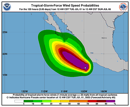
Wind Speed Probabilities last updated Mon, 30 Jun 2025 21:22:18 GMT