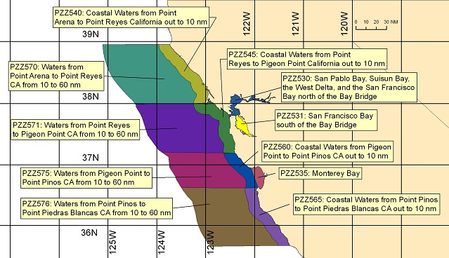
 PZZ535-191615-
 Monterey Bay-
 837 PM PDT Sat Jul 18 2026


 TONIGHT
 NW wind 5 to 10 kt, easing to around 5 kt after
 midnight. Seas around 3 ft. Wave Detail: W 3 ft at 7 seconds.
 Patchy fog after midnight.

 SUN
 W wind around 5 kt, rising to 5 to 10 kt in the afternoon.
 Seas around 3 ft. Wave Detail: W 3 ft at 8 seconds. Patchy fog in
 the morning.

 SUN NIGHT
 W wind 5 to 10 kt, easing to around 5 kt after
 midnight. Seas around 3 ft. Wave Detail: W 3 ft at 8 seconds and
 S 2 ft at 16 seconds. Patchy fog after midnight.

 MON
 Light and variable winds, becoming W 5 to 10 kt in the
 afternoon. Seas around 3 ft. Wave Detail: W 2 ft at 8 seconds and
 S 2 ft at 12 seconds. Patchy fog in the morning.

 MON NIGHT
 W wind 5 to 10 kt, becoming NW after midnight. Seas
 around 3 ft. Wave Detail: W 2 ft at 8 seconds and S 3 ft at
 12 seconds.

 TUE
 N wind around 5 kt, backing to W in the afternoon. Seas
 around 3 ft. Wave Detail: NW 2 ft at 8 seconds and S 2 ft at
 12 seconds.

 TUE NIGHT
 W wind 5 to 10 kt, becoming SW after midnight. Seas
 around 3 ft. Wave Detail: W 2 ft at 7 seconds and S 2 ft at
 12 seconds.

 WED
 NW wind around 5 kt, backing to W in the afternoon. Seas
 around 3 ft. Wave Detail: NW 2 ft at 8 seconds and S 2 ft at
 10 seconds.

 WED NIGHT
 W wind 10 to 15 kt, becoming NW 5 to 10 kt after
 midnight. Seas around 3 ft. Wave Detail: NW 3 ft at 5 seconds and
 S 2 ft at 9 seconds.

 THU
 NW wind around 5 kt, backing to W 10 to 15 kt in the
 afternoon. Seas around 3 ft. Wave Detail: NW 2 ft at 6 seconds.

 THU NIGHT
 W wind 10 to 15 kt, becoming NW 5 to 10 kt after
 midnight. Seas 3 to 4 ft. Wave Detail: NW 3 ft at 6 seconds and S
 2 ft at 14 seconds.

 Locally lower winds and seas across sheltered portions of the bay.


 $$
|